Land-use and an ecological plan around the Bot Estuary.
A land-use and an ecological plan around the Bot Estuary is necessary as a first step in establishing a sound,…


The Bot Estuarine Management Plan covers the area from Hawston, through part of Afdaks Trust land, Including Meerensee and Fisherhaven, across the Estuary to Kleinmond. It will be the master for the development of the new Bot Estuary breaching and management plan, which is about to come out. There are a number of comments on this site about the breaching of the Estuary. These appear under the category Eco Bot Estuary Breach.
The Bot Kleinmond Estuarine Management plan was gazetted in January 2022, with an allowed comment period until the 4 March 2022. This was apparently circulated to some Botfriends members as an e-mail with no attention brought to them about the drastic effect this would have on the immediate surrounds of Fisherhaven by the Fisherhaven representative on the Bot River Estuary Forum (BREF).
Klaus Schmitt was able to obtain a copy days before the closing date for comments and made some brief comments which were accepted. Klaus also emailed his comments to other interested parties.
Mike Austin received a copy of the draft and forwarded a copy to the Fisherhaven Homeowners and also briefly commented on the draft, dated August 2021, including a link to the 2009 draft (the only copy available on the internet. BotKMD EMP_v10_January 2019.pdf (westerncape.gov.za). This was circulated wildly in Fisherhaven and after numerous comments was included in the Fisherhaven Rate Payers (FRA) meeting (now the Fisherhaven Homeowners). Mike and Klaus addressed, the well attended, meeting on the issues raised by the document. These were unanimously accepted and a way forward was to establish an open group, to select members to represent Fisherhaven and to establish a meeting with concerned parties especially the OSM and Cape Nature about the Bot Estuarine Management Plan.
Klaus’s written comments are attached below, as is a copy of the gazetted draft dated January 2022. For the sake of completeness and availability this can be read here or it can be downloaded from this site.
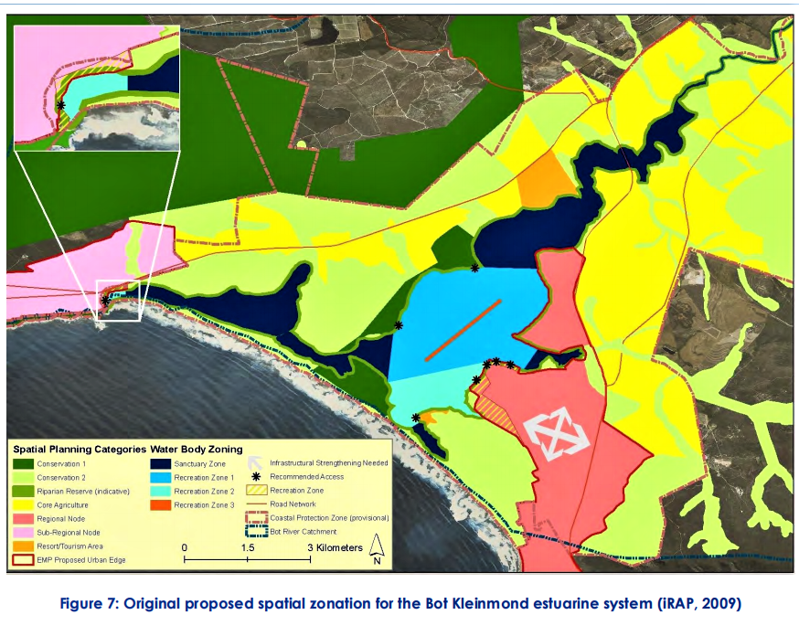
Copy of the map on page 49 of the Bot Estuarine Management Plan showing very little protected area on the east bank of the estuary and inconsistent with the guidelines set out in the same document, which has been gazetted and will therefore be document used for further development.
The comments by Klaus on the Bot/Kleinmond Draft Estuarine Management Plan are also available here or can be downloaded.
FRA Draft comments on land use as per Bot Estuary management plan by Mike Austin, March 2022
History
The BREF meetings kept informing us we were still waiting for the document. In January it was gazetted with a comment period lasting until 4 March 2022. The Estuary breaching plan was awaiting the management plan.
Most Fisherhaveners did not even know about the plan until 4 March 2022. Klaus had found a copy and sent in a comment on time which was accepted. It at least gives us a wedge into maybe been able to influence the proposed plan. History tells us that the comments may be noted, but very little else will be changed. In fact, there have been no real changes since the 2019 draft.
Within the document they use the 5m contour line as part of the no development around the Estuary area, except for existing development below this line, In Hawston, Meerensee and Fisherhaven.
A few years ago, Cape Nature redrew the Kogelberg Biosphere line to exclude most of the east bank of the Estuary to about the 2.5-3m contour line. When I questioned this, they sent me a copy of the old map and did not admit they had made a mistake. They also claimed at BREF that the Estuary was defined as the boundary of the water when the Estuary was in an open condition, that is around the 0m contour line.
The map on page 49 of the report shows the whole area between Fisherhaven and Hawston as development area. This extends down to the water’s edge from Boundary Road and Seaway. Four proposed new access points, i.e. slipways etc along the Estuary have been made. Below Riverside and along the Afdaks section is mapped as along the water’s edge. The rest is zoned Agricultural still. It is suggested in the report that OSM should rezone this. A look at the contour map shows that most of this area is below the 5m contour line.
This is very different from the Rooisand side of the Estuary where proposed new green areas are proposed above the 5m contour line extending up the mountain. This of course excludes Arabella, which can extend down to the water’s edge. Benguela Cove has a defined environmental area along most of its Estuary edge as defined in the EIA for Benguela’s development.
As a matter of interest, the EIA for the development happening below the R43 and against Hawston, excluded a large area from development as been part of a wetland area. The new Afdaks development allows a sewer pipe connection right through the middle of this wetland corridor. Comments by DEA&DP, Cape Nature and Botfriends were noted and a section of the initial plan was left out of the original EIA for Afdaks development. This was then approved. The oldest trick in the book is a new EIA is now going through which allows housing on the old sand mine and the destruction of the wetland between the development and the sewer works, with a main sewer pipeline, cutting through a previously declared green area. In the post on the Afdaks Trust Development, I predicted that this is what was likely to occur. This whole area is now listed as a development area.
Conclusions
The report basically abandons the east bank of the Estuary to full development and puts the ball squarely into the OSM court. Cape Nature is the listed authority on the Management plan. The Kogelberg Biosphere and at least the 5m contour line is abandoned on this side of the Estuary, except for some small patches at the exit of the Paddavlei and a small part of the Afdaks section of the Estuary.
In the future any detailed development beyond Boundary Road and Seaway Including the Yacht club Erf, will require an EIA. But the scene has been set by this proposal. This will result in the usual incremental process which will bring very dense housing right up against Fisherhaven. Probably with the development of Erf 775 from the Yacht Club around the corner into Seaway. Later followed by a development proposal of the section from China Marais and Farm Road through to Hawston, which will have minimum density ratings at least as much as the Afdaks development.
Complicated, interactions of numerous reports which makes it difficult to forsee what is coming. I will try to answer any questions you may have. Primarily, we need to decide on a way forward with our voices being heard.

Recent Comments