Land-use and an ecological plan around the Bot Estuary.
A land-use and an ecological plan around the Bot Estuary is necessary as a first step in establishing a sound,…

A land-use and an ecological plan around the Bot Estuary is necessary as a first step in establishing a sound, stable, economically viable and sustainable environment around the critical Bot River Estuary in the Hermanus area of the Western Cape in South Africa. Historically, this area has not had much of an ecological plan and is becoming the main area for the future growth and development of Hermanus. The ecology of the area has been allowed to deteriorate drastically over the past decades. It now has the highest fire risk and is the most invaded by alien species within the Overstrand. It also has one of the most polluted areas within Hermanus and this accumulation of pollution is now starting to seriously affect the Estuary itself. Without a detailed environmental plan for the areas surrounding the Estuary we are now operating on disaster management guidelines which are costly and repetitive rather than working with nature for a sustainable future.
Where and Who is involved.
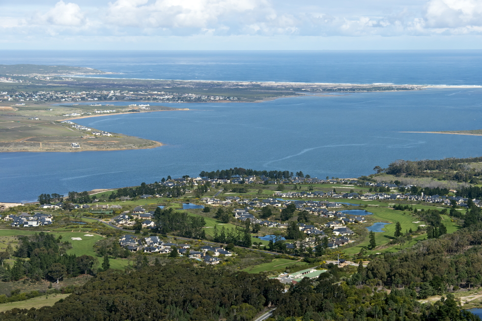
The area that this focuses on is the Bot River Estuary and its surrounds. This occurs in Hermanus (Ward 8), Western Cape, South Africa. It is part of the Kogelberg conservation area and the Estuary is a declared RAMSAR site.
It therefore, involves the whole community which includes built up areas, partly protected green areas with both public and privately owned areas. Many different stakeholders and groups of people with overlapping interests and use of environmental services, provided by the area are concerned. The land-use and lack of an ecological plan for the surrounds of the Bot Estuary are currently of great concern to many of the residents of the area.
What are the issues.
Land-use is the main issue of concern around the Bot Estuary, second only to the lack of an ecological plan. The boundaries of different land users were determined decades ago with very little environmental knowledge at that time. Even today assessments and planning of projects are often approved without a full integration of how surrounding users will be affected. An ecosystem approach needs to be used which has very different boundaries to existing land boundaries. The demands of individual owners of pieces of land are very different from each other. All these demands need to be taken into account when planning a system for the whole area. This makes a complex environmental system with many different interacting variables even more complex to design an overall environmental land use plan.
However, as complex as the land-use and ecological plan for the Bot Estuary and its surrounds seems to be, it is not that difficult to start. Greenheart Projects has already made a significant start in clearly identifying the main problems and a basic assessment of the resources available. There are many reports and analyses of smaller areas, made within the area. However, they are not integrated into an overall idea and plan for the whole area. There are over 100 reports, comments analyses and data which concern the Bot Estuary environment, on the Greenheart Eco blog page or the Greenheart Facebook page and other pages such as the Fisherhaven Homeowners page made by Michael Austin. A number of publications also exist in the Village News and other local newsletters. Most of these are referenced on the Greenheart blog post with appropriate links.
No reasonable ecological plan of land use exists for this area. An assessment of the existing land use is the first step needed in trying to design an overall plan for the area. This will be updated in time as conditions and demands change over time.
The main environmental issues and driving forces can be grouped into
These issues are different for built up areas with houses and other infrastructure, than with more natural areas. The head of the United Nations Environmental Programme (UNEP) has called many times for towns and cities not to be left out of Biosphere areas such as the Kogelberg Biosphere. These areas have very large effects on the surrounding environmental areas Publications & Data (unep.org).
Why do we need a sound plan for the Bot Estuary?
In order to provide an overall land-use and ecological plan for the Bot estuary, which will provide a stable, sustainable environment for the future. This environmental plan must provide natural ecosystem services to benefit most of the people most of the time, especially for the future. Costs and techniques must be reasonable for the long term. The idea is mostly to tip the balance in favour of nature so that nature will do most of the work for us with lower costs in the future.
A major factor to be taken into account is climate change. This is already happening on a global scale and local scale. The people who live in or use the ecological services can make a difference in this area.
The built-up areas due to their greater interactions with the environment cannot be excluded from such a plan. They have a much greater influence on biodiversity, pollution, water and wetlands.
Various smaller groups within the community will be more interested in certain aspects than other aspects. The overlapping of interests of public and private land ownership will have a great influence on such a plan.
When do need this land-use and ecological plan for the Bot Estuary?
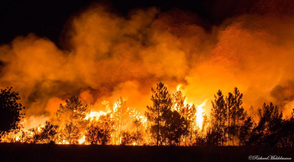
An initial assessment of the area shows that time is already running out. There are still areas with good habitat within the area. Unfortunately, much of the area is degraded. Biological alien species invasions are continuing at an alarming pace. This decreases biodiversity alarmingly from plus 400 species to as few as less than 10. Fire risks are alarmingly high with much greater biomass to burn and most of the time much more intensive fires from the invasive species. Indigenous species are adapted to fire and burn with a much lower intensity.
With urgent interventions most of the area can be recovered at reasonable costs. Clear problem identification and therefore, the right management will allow nature to do most of the work for us. Prevention of wild fires is considerably cheaper than trying to control wild fires. Never mind, the cost of damage to infrastructure of uncontrolled fires.
Where do we concentrate our efforts?
Wetlands become the major focus as they have the greatest biodiversity and lock up more carbon than the forests of the world. They also carry the most water and move and concentrate the pollution. They can also can be managed and are able to deal with pollution with timely follow ups.
Corridors which allow the movement of flora and fauna between large bodies of water and the mountains need to be defined linking wetland areas. These are most important in built-up areas where they have been historically ignored or covered over. Fire, which is a natural feature of this area are likely to be much higher risk in these corridors because of greater biomass production. The risks of damage to infrastructure need to be reduced. This can be done by increasing biodiversity, managing alien species and retaining water in the wetlands.
How and what to do
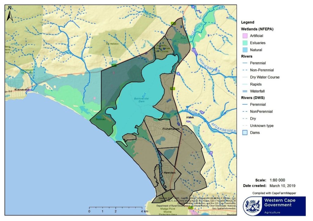
The first step as suggested by the National Biological and Biodiversity Report was to assess the current situation of the area. This was done of the area in 2018. This report was on the geology and the current status of biological and biodiversity of the environs of the Bot River Estuary, both west and east banks. Existing boundaries of parcels of land were demarcated within the ecological area as reference points.
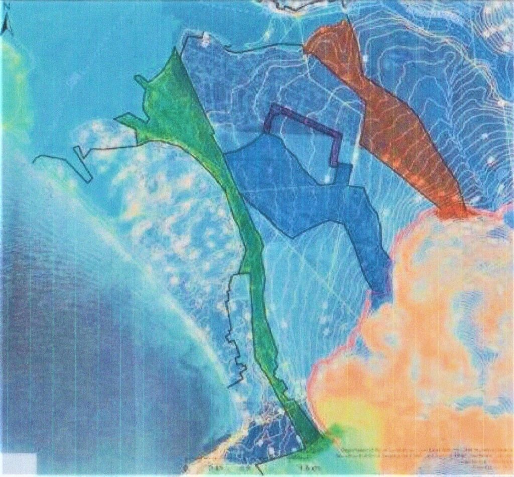
The Paddavlei river system from its source, Hoek van die Berg, through the open water Paddavlei, Skilpadsvlei, down to the Bot River Estuary had an initial report produced. This report was workshopped by the DEA&DP. Finally, an environmental assessment report was produced and finalised. Part of the Afdaks River system has an environmental report done which is in the final stages for the Afdaks development area. Development is presently taking place on a parcel of land adjoining Hawston, below the R43.
A pilot project on alien clearing was conducted on 20ha of green spaces in Fisherhaven. Detailed costing was produced for different categories of invasions of alien species. Cost effective techniques for clearing were established for a very limited budget. The project was 100% funded by donations of both cash and time from the general public. A number of reports were published on social media of conclusions from this project.
Wetland areas were established and mapped and flora and fauna corridors were proposed. These corridors include all wetlands areas and effectively link the Estuary and sea to the mountains on the east bank of the Estuary. These corridors will be finally mapped and more accurate boundaries established once further clearing has been done to provide access through overgrown vegetation.
The west bank of the Estuary is more straight forward and still requires clearing of dense stands of alien plant species invasions.
Benguela Cove has spent a considerable amount of money on clearing and is in good shape with now vastly reduced costs. A recent disastrous wild fire has opened up much of the west bank and head of the Estuary for a better assessment of that area.
The status of the east bank is presently in worse shape than it was in 2018 with the proliferation of denser stands of alien vegetation over most of the area. Some small wetlands have been altered beyond rehabilitation or destroyed, primarily by no management or poor management techniques.
The mountain area on the east bank is in reasonably good shape and an interest has been declared in establishing a protected area. This should be encouraged and more clearly defined on ecological grounds. Potential risks of frequent fires originating from surrounding areas is the main concern followed by limiting alien invasive species. Access to limiting fires from spreading into these areas is thus of major concern and needs attention combined with maintained fire breaks for control.
On the west bank the R43 acts as a convenient firebreak for the immediate surrounds of the Estuary. Attention needs to be given to establishing a fire break and access at the base of the mountains. This would divide the area into three different fire zones.
The built-up areas need to have clear access and fire breaks to limit wild fires from entering built up areas. These need to maintained by cost effective ecological management techniques. Within the built-up areas the potential spread of fires requires reducing the fire risk primarily by reducing alien invasions. It has already been demonstrated that the seedbank can be reduced in the short term and long-term costs can be considerably reduced by the application of the correct techniques of clearing alien species. Existing legislation on the control of alien species needs to be well explained and enforced. With proper long term control, alien vegetation could be almost eliminated from these areas in 10 to 12 years. This would require eliminating seeding of alien species within the whole built-up area and a significant reduction in seeds from surrounding areas. Timing has been the main problem in the past, which makes the costs increase rapidly. The incorrect techniques cause timing to be even more critical.
Public land needs to be more clearly defined on environmental priorities. The fire risk needs to be the driving force. Public land does include most of the waterways and wetlands where the high biodiversity is most important. The corridor idea takes account of most of the wetlands. Some of the proposed corridors and wetlands are interrupted by private land ownership. These individuals need to integrated into the smaller group of stakeholders for each corridor. Existing infrastructure and proposed infrastructure need to allow water flows into these corridors and control pollution into these waterways. Public lands are most used by the general public and tourists to these areas. The reduction of soil erosion and increased water flow and water retention will reduce fire risks. This can best be achieved by the elimination of alien species from the corridors. The control of rapidly expanding reeds into water bodies and along waterways needs to controlled. The main reason for this is that expanded reed beds clog the waterways with a single species, reduce biodiversity to almost nothing as there are no longer natural controls operating. However, reeds can be used to capture pollution, limit silt accumulation in open water areas and remove nutrient loads. In order for this to happen we need to become the natural control by harvesting the reeds regularly to remove the nutrients. Fire in the reed beds does not achieve this as most of the nutrients are returned to the base of the plants as ash and simply continue to accumulate. In time a natural balance will be re-established and nature will be doing most of the work for us.
Farm land is generally privately owned. Waterways need to be protected. Fire risks reduced. Areas not actively used need to have alien species removed which is a legal requirement. Fertilisation and pollution need to be controlled with no run-off into waterways. The use of correct techniques will achieve cost effective, long term, stable and sustainable environments. Education and demonstration are the key here. It may require some financial assistance initially, in order that alien seeds are not spread onto surrounding areas.
What is probably the main reason for the apparent failure of control measures of alien vegetation in the past has been the lack of timely follow-ups. Some few areas have aptly demonstrated that the elimination of alien species is achievable, if conducted at a large enough scale with all role-players involved. Costs can reduce considerably even in the short term with correct techniques and timely follow ups. The services rendered to the community by natural, stable and sustainable ecosystems can be considerably increased. Working with nature requires that we tip the balance in favour of nature rather than working against nature. On both a local scale and a global scale working against nature is the primary cause of climate change.
The thread running through this is that the control of alien species is the first and most important step we need to take. Historically, we have allowed this problem to run away from us. This is not a new problem, particularly in Ward 8, this has changed for the worse in the last two decades. The indigenous vegetation seedbank still exists in most areas and it has been demonstrated in Fisherhaven that not much effort is required to re-establish natural vegetation which can then outcompete the alien species and maintain the balance in favour of low fire risk, increasing biodiversity, re-establishing wetlands with clean water outputs, reduce pollution and correct land use supplying much greater services to the whole community. Future developments need to be assessed on the basis of a sound environmental plan and integrated into the plan. A detailed budget on an alien clearing program was drawn up in January 2020, for an expansion of the pilot project in Fisherhaven. No funding was obtained for the expansion. It needs local government support. A revised project has been put to the Overstrand Municipality, 2022, and we await results.
Conclusion
A land-use and ecological plan for the Bot Estuary has much of the basic work already done. A detailed plan was made of the Paddavlei River ecosystem, workshopped by the DEA&DP and published through the Hawston Development Association (HDA) and the Paddavlei Eco Group (PEG), June 2017. An analysis of the whole area was conducted and the current status of biological invasions was established and reported on (revised January 2020). In addition a pilot project of clearing alien plant species was carried out over 2 years to establish the most cost effective techniques. Proposed corridors were established to include all the wetland areas on the Hawston/Fisherhaven side of the Bot Estuary after detailed ground truthing in the area.
Detailed reporting on the ecological damage which occurred from poor management of the breaching of the Bot Estuary was reported on and given to the Bot River Estuary Forum (BREF), including mistakes in their report. An issue with the Bot Estuarine Management Plan, was reported on and raised through the Fisherhaven Homeowners Association, 14 March 2022. Most of the wetlands on the Fisherhaven/Hawston side of the Estuary are listed for development in this report which has closed for comments and is to be gazetted soon. This resulted in a well attended meeting, with full support for a delegation to raise the issues with the Overstrand Municipality. The meeting occurred, but we await some results and follow-up.
The testing of techniques and detailed costing and analysis of the pilot project in Fisherhaven is ready to be expanded to the whole area. A detailed land-use and ecological plan for the Bot Estuary can then be made. Timing is becoming critical. The details including costing have been established and only require local backing and initial funding. With this in hand additional funding can be leveraged for the whole project.
Michael Austin Greenheart April 2022
The services we get from nature include: A brief summary
Provisioning Services -material benefits
Regulatory services -benefits from regulating air, water soil fertility
Supporting services – necessary for all other ecosystem services
Cultural services – non material benefits

Recent Comments