Land-use and an ecological plan around the Bot Estuary.
A land-use and an ecological plan around the Bot Estuary is necessary as a first step in establishing a sound,…

The status of biological invasions of the Bot River estuary and immediate environs. M N Austin, April 2019. Botfriends, Fisherhaven, South Africa.
This report was made on the recommendations contained in the national report of 2017 in the link below
A current report on the status of biological invasions of the environs of the Bot River Estuary does not exist. Any project or proposal of trying to deal with invasive species or environmental management needs to have an assessment of the current status of the biological invasions and geology of the Bot Estuary environment as a yardstick to measure the progression of improvement or deterioration of the environment. This document is a simple start which can be built on in order to assess the current management needs of this area.
The national report on the status of biological invasions and their management has recently been released by Minister Hanekom (Van Wilgen et al 2018). This extensive, extremely well-written report is the first attempt to assess the status of biological invasions at a national level. The major conclusions of the report which are relative to this area are that:
• The Western Cape is the most invaded province
• The Fynbos Biome is particularly at risk
• Of the 13 worst invasive species in the country, Port Jackson, Rooikrans, pine and gum occur as the main invasive species in this area, together with Australian Myrtle
• SA invasive species regulations are substantial and robust
• Large sums of money have been spent on the control of terrestrial and freshwater species, but have been generally ineffective
• It is imperative to improve management efficiency, and lack of adequate planning and monitoring of outcomes is the major weakness in invasive species control operations in South Africa
• Positive returns on investment from spending on invasive species control is possible especially in terms of reduced fire hazard, increased clean water retention and social benefits associated with alien species control programs.
A draft of the Western Cape Biodiversity Bill was released for comment. Mike Austin, as Botfriends commented on this bill. An earlier report on Biodiversity & Biological invasions in Ward 8 has a copy of the national report. Aliens species proliferation in Ward 8 summarises the Ward 8 situation.
This report provided the basis for the Botfriends Challenge, comments on the environmental impact assessments, the Botfriends Alien Clearing Program and is within the aims and objectives of Botfriends. The report also provides the basis for comments on the Paddavlei, the management of Bot Estuary and even comments on climate change effects within this area.
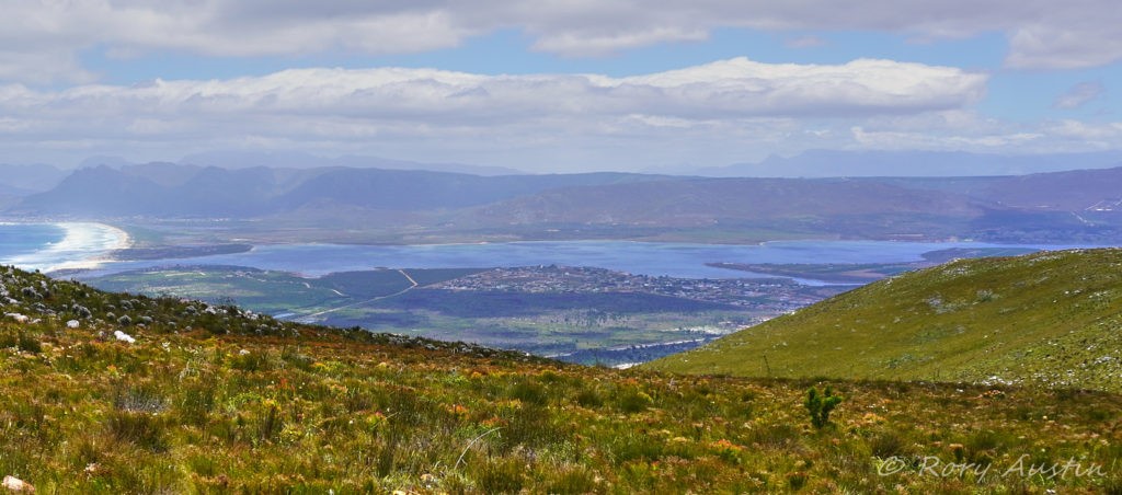
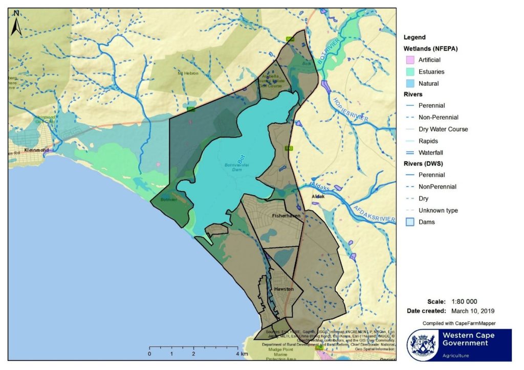
A brief assessment of the current situation of biological invasions of the Bot Estuary areas adjacent to the Bot River estuary (Fig. 1) follows with comments on the broad soil types and an assessment of the invasion status of each area.
Most of this area consists of soils with a diagnostic ferrihumic horizon (Fig. 2). In the southern area they tend to be shallow with colluvial and alluvial sand, capable of growing shortish fynbos, classified as Gb 4 (Appendix 1). Close to the estuary and along the sea are grey regic sands, fairly undifferentiated and more prone to invasive species without careful management, classified as Hb 27. The area around Arabella and stretching north from Arabella are deeper soils with a higher production potential, classified as Ga 14. Generally this area gets significantly more rainfall than the eastern side of the estuary, because of its proximity to the mountains. It has developed deeper soils, with a higher clay content, with better water-holding capacity and better nutrient status and is therefore capable of much better vegetation production of fynbos, with greater species diversity. However, these conditions lead to greater growth production of invasive species.
Rooisand Nature Reserve (217 ha) is generally in good condition, well-covered in fynbos, supplying good competition to invasive species and relatively cheap to maintain, the soils are classified as Gb 4 and Hb 27. A few hectares of the south west are invaded with Rooikrans which can be relatively easily removed. Follow-ups will be required as this area consists of deep, undifferentiated sands and will take time for fynbos to re-establish.
Farm Re 892 (455 ha), has recently been cleared and most of it has reasonable cover of the pioneering fynbos species and a good grass component. This acts as an ideal buffer zone from further invasions from the west. Most of this area is classified as Gb 4 and Hb 27 along the sea coast, sand dunes. A section just inland from the coast is classified as wetland areas, this is the Lamloch swamps and periodically flooded areas.
Farm RE 563 (352 ha) is a mixed bag with rather severe invasion of mostly Port Jackson and Myrtle, especially below the R44 and the southern end. It has a large grassy area in the centre. The northern end with deeper soils, is predominantly invaded by a mix of gum and Port Jackson. However, a significant number of the taller fynbos species persist, including Protease species. This area should be cleared especially to reduce the seed source to Rooisand nature reserve and Farm 565. This all falls within Gb 4 soil classification.
Farm 565 (76 ha) consists of well-cleared, well-established Fynbos, kept clean by Cape Nature. This is a prime example of what the surrounding farms can be, especially all the area below the R44, classified as Gb 4.
Farm 1/542 (314 ha) is a mixed bag with gum and pine species, Port Jackson and Myrtle interspersed with the taller species of Fynbos including Protease species. The southern end is classified as Gb 4 below the R44, slightly deeper soils on the northern end, Ga 14. A section adjacent to Farm 565 is being cleared and parts of it have establishing a good cover similar to the species mix on Farm 565.
The remaining area especially below the R44 needs to be cleared soon to allow the rapid re-establishment of fynbos and reduce the very high fire risk to surrounding areas.
Arabella, Farm portion 274/542 (19.3 ha) has been cleared of severe invasive species and they have an environmental plan in place. These are deeper soils classified as Ga 14. Much of this area is established as lawns.
The narrow strip above the R44, before the steep slopes of the mountain, is also a mixed bag. Some parts are reasonably clear and some parts are severely invaded, especially on the deeper soils where extremely good growth of invasive pine and gum species is occurring, (the main invasive species of this area). These are classified as Gb 4 in the south and deeper soils Ga 14 in the north.
Farm 2/542 (273 ha) is a commercial farm with a mix of pastures and planted trees interspersed with invaded gum and pine. This sits at the head of the estuary and the area to the North and West consists mostly of deeper soils put to commercial use, Ga 14. The southern and eastern section needs some further attention and parts are severely invaded with pine, gum and Port Jackson and needs some attention.
The eastern side of the estuary generally consists of shallower soils, less weathered because of the lower rainfall, lower clay content and thus lower water-holding capacity. The north eastern edge of the estuary consists of soils that are prismacutanic and/or pedocutanic diagnostic horizons where the B horizon is mainly not red. They are derived from siltstone, mudstone and shale of the Bokkeveld group with alluvial sand in the valleys, classified as Db 223 deeper soils in the north and Db 105 (the shallower version) in the south. These soils become shallower the further south one goes and in Fisherhaven they change to grey regic sands and other soils, classified as Hb 27. These are recent coastal sand and dunes which may be very deep in places, often saline with generally a very low nutrient status. The shale derived soils may have been partly buried in places by regic sands and the species composition can vary considerably over very short distances. Most of Fisherhaven, Meerensee and Hawston consists of regic sands with Meerensee and Hawston west of the Paddavlei River to the sea consisting of sand dunes prone to blowing. Port Jackson and Rooikrans were introduced to this area from Australia, in an attempt to stabilize the dunes. The vegetation consists mostly of Port Jackson and some Rooikrans; there is very little evidence of fynbos species, with scattered patches of open sand.
Farm 2/541 (89 ha) was until recently ploughed and is now mostly grassland for grazing. Some patches are severely invaded, primarily by Port Jackson and Rooikrans along the shore of the estuary. The area is classified as Db 223 soils.
Benguela Cove is mostly vineyards and is well-maintained with a strip along the estuary of well-kept fynbos. The farm is classified as Db 105. Some areas which were cleared of all vegetation and then not used as vineyards are in the process of rehabilitation. These areas have a good cover of indigenous grasses with a smattering of shrub species, spreading into the grassy areas. They have extended clearing into the road verge section. This area is a good example of what can be achieved in a relatively short time and with continuous follow-up treatments in the control of biological invasions around the Bot Estuary. There is now minimal alien seedling germination, mostly confined to the edges of indigenous vegetation blocks where some disturbance is ongoing. The good stand and cover of indigenous vegetation is outcompeting alien seed germination and therefore the cost of ongoing maintenance has been reduced to a minimum. Alien invasive seed source within the estate has been reduced to very little; the only input is from surrounding areas. Natural deterioration of the huge seedbank has proceeded well and even in recently disturbed areas, very few alien seeds grow. The fire hazard has been severely reduced and has been pushed back onto surrounding property areas, some of which are covered in 100% alien species with the attendant very high fire risk.
Farm portion RE 541 (1058 ha) is mostly commercial with wheat fields. The balance of it is used for grazing and appears to have been kept free of invasive species. Most of the wheat fields are classified as Db 223 and the grazing section is classified as Fa 208.
Farm portion 2/575 and 19/575 (411 ha & 52 ha) are mostly commercial wheat fields. The river valleys are moderately invaded and need some attention. Both of these sections are classified as Db 105.
Farm portion 21/575 (717 ha) has some severely invaded areas. Much of this was ploughed before, but has been abandoned. This area is mostly classified as Db 105, but the soils tend to be shallow, with a small section of Hb 27. Much of the farm has a grass cover on the abandoned lands, maintained by a lack of fynbos species seeds from years of cultivation and too frequent fires in the recent past. The river courses and wetland areas are severely invaded and are spreading into the grassland component. The section west of the R43 has mostly Port Jackson which has invaded into the estuary and poses a severe fire risk where it borders Fisherhaven and Benguela Cove. Between Fisherhaven and Hawston, the most severely invaded areas above the R43 are in the process of being declared a township expansion area. Unfortunately, the invasion is spreading to the upper slopes, which the proposed EIA (Environmental Impact Assessment) for the township expansion specifies must be cleared of alien species. These upper slopes are presently abandoned from an agricultural point of view, with frequent fires occurring.
Farm portion 7/575 and 573 (13.85 ha) border on the Afdaks section of the estuary, classified as Db 105 This consists of short fynbos which has had bad management in the past. It has recently been cleared of invasive species, with properly-managed techniques and two follow-ups of seedlings having been done. Unfortunately, there still exists a seedbank of Port Jackson, especially on the eastern end, with seed from the severely invaded, mature Port Jacksons on Farm 21/575. Some planted shrubs which are not indigenous still remain, but at present are not spreading. Some indigenous shrubs, that were no longer present in the area due to previous bad management, have been successfully re-introduced. This area needs legal protection to protect the well-established indigenous vegetation. The clearing work and follow-ups that have been done on these two sections were done by private funding and volunteers. The area is still zoned for agricultural use. Bordering on the estuary, they need to be rezoned as green areas.
Fisherhaven municipal area around the Bot Estuary, which generally has severe biological invasions.
This area has extremely variable soils, ranging from deeper and shallower soils classified as Db 105, to shallow and deep grey regic sands, Hb 27. Many of the shallow soils are periodically flooded, in parts with internal drainage areas exacerbated by road construction and inadequate drainage. The great variety of soils, with large changes over short distances, has led to a great variety in species composition. Extensive species lists have recently being compiled on public spaces and show that the biological diversity is much higher than was previously documented. The area ranges from extremely invaded areas, especially in the last decade, to less invaded areas. The human interference and the lack of an environmental management plan has led to severe invasions of both alien and indigenous species invasions. The incorrect application of clearing techniques compounds the problems and, in some cases, has led to great social and economic loses. The costs now involved in re-establishing natural vegetation in some areas have become not economically viable. The fire risks have increased dramatically and illegal techniques are now being proposed for reducing fire risks that ignore environmental legislation. This area consists of public open space and privately-owned erven. Environmental legislation needs to be applied to privately-owned erven, to halt the spread of alien seed, especially onto green areas. This will also reduce the fire risks which are building to unacceptable levels. Many of the public open green spaces have recently been cleared of invasive species, with properly managed techniques, with follow-up clearing operations. This is ongoing and done by private funding and volunteers and has been extremely cost-effective. These green spaces constitute 15.27 ha. These areas will require follow-up clearing of alien seedlings and it will take time for the fynbos species to re-establish themselves adequately, and supply strong competition to invasive seedlings growth. These areas need to have proper legal protection to protect them and the work that has been done on them.
The fire risks have been considerably reduced. Unfortunately, 5.9 ha of public open green spaces have been so badly managed in recent years with incorrect management techniques that a decision needs to be made whether they are worth salvaging. These areas have become an ecological desert. These management techniques were applied by the
OSM on land which they are legally bound to manage. With no overall plan and no feedback from government, private capital and time cannot be spent on these areas. The amount of public funds already spent on these areas far exceeds the amount spent on the properly-managed 15.27 ha. More funds spent on temporarily reducing the fire risk by applying current poor management techniques will not only enhance the ecological desert, but will necessitate ongoing high yearly expenditure for the foreseeable future, in order to control the severe fire risk build up.
A section of public green space of 115 ha has been not been managed at all. A small piece of it gets mowed as a firebreak, which has destroyed the fynbos species, and consists of grass, Port Jackson and Myrtle, which is forming a carpet under the mowing regime. This coincides almost exactly with the most sensitive biological component of this block.
The rest of the area consists of a mixture of Port Jackson, Myrtle and pine which was standing more than 3 metres high. It also has greater than 30 000 cubic metres of garbage and rubble dumped on it, most of this in the last few years, but some of has been there so long that grass and other weeds have grown over it. This was such a severe fire risk that it was abandoned. Most of it burned out this year with an uncontrollable fire in very gentle conditions. The standing dead tree trunks and the massive germination, especially of Port Jackson (extremely flammable, even as young plants) will pose an even greater fire risk within a year. The area consists of deep regic sands and a series of wetlands. The wetland corridor needs to be rehabilitated and cleared of invasive species, in order to both re-establish
the wetland functions, and to provide for a corridor of green area for the free movement of both flora and fauna.
No overall environmental plan exists for this area, which has led to no management strategy, or to environmentally destructive emergency management techniques being applied. Other than the corridor joining the wetland areas, the rest of this area is probably not economically viable to rehabilitate and may as well be subdivided for future housing. An interim management plan needs to be put into place to reduce the severe fire risk. Attempts have been made to put together an overall plan for the area but government has done nothing. The costs of future management decisions are increasing at an alarming rate on a logarithmic scale.
Other green spaces within Fisherhaven reserved for other amenities such as schools have great biological value. It is unlikely that these will ever be used for community purposes. The natural vegetation should be preserved on these areas with correct management techniques. In the past, these areas have been mowed, or randomly sprayed with herbicide, which destroys the Fynbos. These are worth saving and not turned into ecological deserts, as has happened by applying the same poor techniques on some of the other green open public spaces.
Public Works land adjoining Fisherhaven and surrounding Meerensee
This area which consists of farm portions RE 566 (66 ha) and 2/566 (12.2 ha plus 54 ha) borders on the estuary and is classified as Hb 27, with grey regic sands and other soils. There is a mixture of very shallow soils, sand-buried soils and deep sands or dunes. Some of it bordering the estuary and close to Fisherhaven is moderately invaded, primarily by Port Jackson. Most of it is severely invaded by Port Jackson and Myrtle, with a closed canopy. There are substantial wetland areas along the Paddavlei River with severe recent reed growth due to pollution moving down through the area. The area constitutes a very severe fire risk to Meerensee and to Fisherhaven. Parts of the section south of Meerensee are blowing dunes and periodically-flooded areas invaded with Port Jackson and Rooikrans. A permit for clearing the area was issued in 2017, but nothing has been done yet. This area provides an obvious extension of the proposed corridors, through Fisherhaven, and up the Paddavlei wetland area, to link to the water’s edge of the estuary.
Meerensee estate, bordering on the estuary is all classified as Hb 27. It is fenced off and only gated access is allowed. Most of it has been built up and parts of it are declared green areas which seem to be maintained.
Farm portion 244 (99.7 ha) is all classified as Hb 27 and consists of deep sands. A fire through this area a few years ago caused a partial evacuation of Meerensee. Most of this area is severely invaded by Port Jackson. The fire risk is building up rapidly, but is not severe yet.
Farm portion 3/566 (207 ha) consists of deep sands and blowing dunes. This is an especially difficult area to manage and already constitutes a severe fire risk to parts of Hawston with dense stands of primarily Port Jackson.
Farm portion 6/575 (84.9 ha) northern end is classified as Hb 27 and the southern end is classified as Db 105. It consists of mostly shallow soils with some sections of wetlands. A recent EIA was approved with most of it rated not for building except the south east corner. It was cleared poorly a few years ago and substantial regrowth of Port Jackson has occurred throughout the portion, forming a closed canopy over much of the area. The wetland area is an obvious extension of the proposed corridor.
Hawston Built-up area.
This is a mixture of Hb 27 on the western side changing to Db 105 on the eastern side ranging up the mountain with very shallow soils and bare rock. The Paddavlei River flows through the built-up area with two open waterbodies: the Paddavlei and Skilpadsvlei, joined by wetlands. Both water bodies have become reed-infested swamps in the last year with substantial pollution occurring into the Paddavlei from the streets of Hawston. Ten years ago the open water body of the Paddavlei had not varied much from 1938; in the last decade it has now been substantially reduced by approximately 70-80%. A proposed cost effective management scheme has not been implemented. The Skilpadsvlei is severely polluted, primarily from the sewage farm, and has dense reeds growing to 3-4 metres in sections which consisted of open water 2 years ago. Authorities deny the physical evidence of obvious pollution. Extensive invasion of numerous species has occurred alongside, and into, the wetlands. Extensive dumping of rubble and other rubbish is evident throughout the area and particularly into wetland areas, where wetlands have been buried. The whole wetland area and its margins now constitute a severe fire risk. The open water bodies and their associated wetlands are worth saving and would constitute a green corridor through the township area, with much reduced fire risks.
The Hawston area extends right up to the top of the mountain, and provides part of the catchment area of both the Paddavlei and Afdaks Rivers. In the past this area has had frequent fires, which has been very detrimental to the indigenous vegetation, which does not reach maturity so therefore does not generate seed. Many of the long-maturing species have disappeared. Invasive species, particularly Port Jackson have invaded up the slopes. The area is degraded and needs to be rehabilitated. There has been much soil loss and erosion. However, the area can be recovered, water flows restored with a sound environmental management plan. It will probably never reach the status of the Fernkloof Nature Reserve but can certainly provide a stable, sustainable backdrop to Hawston and Fisherhaven and the proposed extensions of these built-up areas. It will contribute to the establishment of three major green corridors linking the mountains to the estuary and the rebirth of the wetland systems through Hawston, between Hawston and Fisherhaven and to the north and east of Fisherhaven.
Farm portion 8/572 (43.13 ha), Department of Transport, 1/572 (13.59 ha) are all classified as Hb 27, consisting of deep, very level sands. This is mostly a sponge area which together with about 50 ha of RE 572 absorbs all the rainfall plus the run off from the mountain area of approximately 60 ha of RE 572 which releases slowly into the Paddavlei and numerous seeps within Hawston. This area is severely invaded with Port Jackson, Myrtle and gum species which use up all the water and has caused the seeps in Hawston to dry up. There is also extensive dumping on sections of 1/572. Sections of these portions need to be classified as green areas to link the Paddavlei corridor to the approved corridor for Hoek van die Berg, which extends up the mountain, thus providing a link from the estuary to the mountains.
RE 572 (463 ha) and 3/572 (21.6 ha) is mostly Hb 27 with shallow and deep sands and some exposed rocks with very shallow soils or exposed rocks on the mountain section. Much of this is severely invaded with Port Jackson, Myrtle and gum trees. Clearing is progressing below the R43. Above the R43 a recent fire has caused extensive germination of Port Jackson and with no follow up treatment, and is evolving into a closed canopy of invasive species on the lower slopes of the mountain. The approved development plan for RE 572 provides for two vegetation corridors linking from the
mountains to the sea. The deep sands area, which absorbs water and provides water through the dry season into the Paddavlei and seeps within Hawston, is part of one of these corridors. The clearing and maintenance of this corridor linked to the Paddavlei corridor will be invaluable in re-establishing the open water bodies and associated wetlands of the Paddavlei corridor. The underlying geology of this area prevents most of the water going south directly to the sea. This underlying ridge extends across RE 572 and extends along the entire length of the Paddavlei River, between the river and the sea, right to its exit into the Bot River Estuary.
The western side of the Bot Estuary consists of a mix of good stands of indigenous species interspersed with moderate to severe, biological invasions of alien-invaded areas. The alien vegetation needs to be cleared to reduce the severe fire risk and reduce the spread of seed into cleared areas. A good seedbank of indigenous species exists which will help with a rapid rehabilitation of the area below the R43. An extension of clearing above the R43 needs to be considered before this extends up the mountain sides.
The northern edge of the estuary consists of moderate to severely invaded strips of land between productive agricultural lands. These are mostly privately owned lands and need to be cleared to reduce erosion and provide water filters for water entering the estuary.
The northern section of the eastern side of the estuary consists of privately owned land, most of which is agriculturally productive. Small areas are moderately invaded and should be cleared to consolidate the indigenous vegetation blocks.
The southern section of the eastern side of the estuary has very poor soils and very little agriculturally productive land. What little agricultural production which occurred in the past has been abandoned. It also has extensive built-up areas which will be expanded in the near future. There is no environmental plan in place for this development and limited ad hoc crisis management techniques have been applied in the last decade, usually leading to further destruction to the environment.
Most of the area is severely invaded by alien vegetation especially the numerous wetland areas, interspersed with a few small areas of reasonably managed indigenous vegetation. Much of the area surrounding the built-up areas, is public land.
Hawston Heights is critical to the whole area as a water catchment area, providing water into three of the proposed biodiversity corridors which will link the many wetland areas. These are the priority corridors which need to be cleared of alien biological vegetation in order to provide biodiversity corridors linking the wetlands of the Bot Estuary, re-establishing the open water bodies and considerably reducing the pollution which is visibly moving down the waterways into the estuary. Additional green spaces within the built-up areas or proposed built-up areas need to be delineated and correctly managed and cleared of alien vegetation. The existing fire risks directly on infrastructure in the area are very high and need urgent attention.
The areas surrounding the proposed corridors need to have a management plan to reduce the severe fire risks and to reduce the potential reinvasion into the corridors and other green areas until such time as they become built-up areas. The mountain areas, including Hawston Heights, which are primarily water catchment areas for the wetlands need to be cleared to reduce the devastating frequent fires, soil erosion and to improve considerably the aesthetics of the environment.
Van Wilgen, B.W. & Wilson, J.R. (Eds.) 2018. The status of biological invasions and their management in South
Africa in 2017. South African National Biodiversity Institute, Kirstenbosch and DST-NRF Centre of Excellence for
Invasion Biology, Stellenbosch.
A discussion document on ‘Land use and ecological plan around the Bot Estuary‘ has been published. This attempts to integrate the numerous factors which may affect such a plan. Biological invasions around the Bot Estuary greatly affect the fire hazard, and water availability and particularly the wetlands around the Estuary. Biological invasions, fire risks and wetland deterioration are the main elements of a stable and sustainable ecological plan for the Bot Estuary and its surrounds. Numerous posts and discussions on these subjects occur on social media, such as Greenhearts Facebook page and recently on Fisherhaven Homeowners page on the management of the estuary. Other publications are on the Village News and other local newsletters. Over 100 posts on various ecological aspects occur on Greenheart blog page under the eco category with its subheadings, which you can access the full list on Greenheart Home page under Categories on the right hand side.
Figure 1 Location of the area of biological invasions surrounding the Bot River Estuary
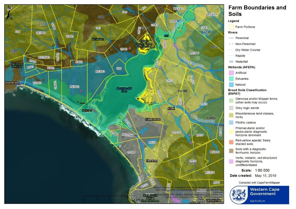
Figure 2 Soil types and existing farm boundaries surrounding the Bot River Estuary
Brief description of the major soil groups within the area of study Soil type and Geology of the estuary environs
Land Type Hb 27
These are predominantly grey regic sands with other soils scattered through the landscape. Soils have limited pedological development, sandy, excessively drained soils. Usually greater than 750mm deep with very little clay, less than 15% with high erodablity (0.64) and subject to wind erosion.
Geology. Recent coastal sands and dunes with a slight occurrence of shale of the Bokkeveld group and sandstone of the Peninsula Formation, Table Mountain Group.
Land Type Db 105 and Db 223
Soils are Prismacutanic and/or Pedocutanic with diagnostic horizons dominant. The B horizons are not red, with strong texture contrast, with a marked clay accumulation, strongly structured. The soils are generally shallow, less than 450mm, and usually less than 15% clay with high erodability (0.66). The Db 223 soils tend to be less shallow.
Geology. Siltstone, mudstone and shale of the Bokkeveld group with alluvial sand in the valleys.
Land Type Gb4
Soils with diagnostic ferrihumic horizon predominantly shallow (Houwhoek Form). There are scattered rocky areas with limited soils. The soils are shallow, less than 450mm, with low clay content, usually less than 15%.
Geology. Colluvial and alluvial sand with rocky areas with limited soils.
Land Type Ga14
Soils with diagnostic ferrihumic horizon predominantly deep (Lamote Form). The soils are deep, more than 450mm, with low clay content, usually less than 15%.
Geology Quartzitic sandstone of the Peninsula Formation, Table Mountain Group. Lower areas consist
of shale of the Bokkeveld Group partly covered by alluvial sand.
Land Type Fa 208
Lime is rare or absent in the entire landscape. Mostly Glenrosa and/or Mispah Forms (other soils may occur). Soils with limited pedological development, usually shallow on hard or weathered rock, with or without intermitant diverse soils, with lime inparts of the landscape. Soils are less than 450mm and less than 15% clay. Classified as high erodability (0.59).
Geology. Quartzitic sandstone of the Table Mountain Group occurs on the higher midslope. Shale,
mudstone and siltstone of the Gydo Formation, Bokkeveld Group on the lower midslope and footslopes.
End…

Recent Comments