Land-use and an ecological plan around the Bot Estuary.
A land-use and an ecological plan around the Bot Estuary is necessary as a first step in establishing a sound,…

The is a copy of the report Michael Austin delivered to BREF (Bot River Estuary Forum) at their meeting in April 2021. There was no real discussion of the report. Comments ranged around the fact that the Comments and other reports He had made should not be on social media (which is why this report had not been posted until now). Limited support was got from one member that I should at least be heard. The BREF chairman then said he would pass the report onto ‘the experts’ to assess.
Other feedback from the BREF chairperson was that a number of other ‘experts’ had been on the beach deciding where the breach should be positioned and therefore it was not a BREF problem (even though the report with errors is published under the Cape Nature banner).
At the subsequent meeting BREF reported that the area of the estuary had been taken into account, and the matter of the breach is closed. This is clearly refuted in the report by the graph and conclusions under the heading ‘Water flow rate’. A basic arithmetic area showing that the volume of water is only related to depth of water and not depth x area (V=length x breadth x depth). In this case area = length x breadth.
Mistakes can are made with the best of scientists, but we need to learn from our mistakes and correct them. No rewrite of the report has been forthcoming. The problem arises when this report remains as the sole facts of the estuary breach and will be quoted as such.
A very unhealthy situation for such an important national and global asset.
BREF is a discussion forum on Bot River Estuary. This is where the general public can make inputs on matters that affect the estuary. It acts like a forum where the public will be informed of Government actions weather they are correct or not and comments and or criticisms are ignored or covered up, to the detriment of the environment. This is one of many such situations where reported pollution events have been ignored or partially solved, partly because of no clear identification of the problem.

This is the report delivered to BREF in April 2021. After their report from Cape Nature on the breach of the estuary in 2020.
This is only now being added to social media, after lack of action from BREF.
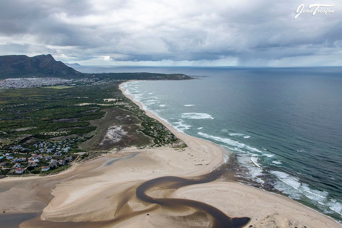
The whole dynamics of the estuary have been changed primarily by the position of the artificial breach.
The report by Cape Nature on the estuary breach and the minutes of the last BREF meeting have ignored these changing dynamics. The further changes which have occurred since the report were hinted at last year but were unlikely to have been able to be predicted to have changed so much. We are now truly in a completely new dynamic.
The report is so basic and has a number of gross errors. The link with the Kleinmond breach is obviously wrong, the Bot reduced its rate of rise, but was still rising on the 21st July 2020. The graphic shows only a height of 2.2m just before the breach and not the 2.5, 2.6m which was observed. The calculation of outflow to Kleinmond appear to be out by a factor of 8x. Had this occurred there would have been a major flood at Kleinmond? The flow rates, after the breach are wrong by a factor of more than 2.
The water volume in the estuary is dependent on the depth of water x the area of the estuary at that time. The report assumes a linear relationship between the water volume and the depth of water only. The data presented ignores the change in area which changes dramatically the fuller the estuary is. The volume from sea level to 0.5 m is the same as the volume change from 2 to 2.5m. This makes the entire report questionable including reported water levels which are tide dependant. Other errors were reported on, including the massive damage already reported.
The environmental damage is what changed the dynamics so drastically. A casual observer can see that minimal tidal action is now occurring. This tidal action varies around the high tide mark 0 to 400mm rather than the low tide mark 0 to 1700mm. With a low high tide very little sea water is even entering the estuary.
Most of the additional sand eroded from the old sand dune, due to the poor position of the breach has been deposited back into the estuary stretching as far back as Die Keel. This has developed into a self-perpetuating system with a continuous up of sand and a weak of no tidal action scouring out sand.
The constant inflow from the Bot River still flows out to sea, but from a level of 1-1.5m with a gentle flow over a long distance at the mouth of the estuary. Even the channel remaining at the mouth has silted up with minimal scouring occurring. Eventually, the estuary may close and the sand deposited so much further into the estuary mouth area will continue to build up.
There will be even less chance of a natural breach occurring. An artificial breach may require a very long channel to be excavated. Especially as such a breach is likely to stabilize at about 1.5m above sea level. This will considerably reduce the scouring effect. The situation will revert to a similar situation as what we have at present, with even more deposit of sand in the mouth area, furthering the changed dynamics.
Only a massive storm during the opening of the estuary, may move the system back towards what it was before the breach. A drainage map of the estuary has been compiled.
The changed dynamics obviously need a changed management plan to replace the existing management plan, which in itself was not achieving its objectives.
Michael Austin April 2021

Recent Comments